Cycling the Loop Head Peninsula: Cliffs and Lighthouses
A 65 km loop past the Bridges of Ross, Loop Head Lighthouse and the Kilkee cliff walk. Fully exposed to the wind, so pick your day carefully.
Introduction
The Loop Head Peninsula sticks out between the Shannon Estuary and the Atlantic, which means it is exposed on both sides at once. That is the thing to understand before you ride here. The sea-cliffs, the lighthouse and the sea arches are why you come. The wind is what decides how the day actually goes.
The standard circuit is 65 km, starting and finishing in Kilkee. Most riders go clockwise: south on the R487 along the northern cliffs, round the tip to the lighthouse, then back along the southern shore through Carrigaholt and inland via Ross. There is next to no shelter on the northern half.
1. The Loop Head Cycle Loop: An Overview
| Item | Detail |
|---|---|
| Total distance | 60-70 km (typical loop), 50 km for a quick ride, up to 90 km for an extended coastal tour |
| Elevation gain | ~820 m total ascent (and equal descent) |
| Average gradient | Gentle rolling hills punctuated by short, steep climbs near the cliffs |
| Surface | Predominantly paved R487 and minor farm roads; some gravel sections near Kilkee Cliff Walk |
| Estimated ride time | 4-5 hours at a moderate pace (incl. stops for photos and visits) |
| Difficulty | Moderate, suitable for confident cyclists comfortable with wind and occasional headwinds |
The loop starts and finishes in the seaside town of Kilkee, a popular base for cyclists because of its range of cafés, B&Bs and bike-hire shops. From Kilkee you follow the R487 south along the northern cliffs, swing east around the tip of the peninsula to Loop Head Lighthouse, then trace the southern shoreline past Carrigaholt and back to Kilkee via the inland road through Ross.
2. Highlights Along the Route
2.1 Kilkee Cliff Walk & the “Candle Stick” Rocks
- Location: Just a kilometre south of Kilkee town, the official Kilkee Cliff Walk is an 8 km (5 km optional) coastal path that runs parallel to the R487.
- What to see: Dramatic limestone cliffs, the striking “Candle Stick” rock formation, and sweeping views of the Atlantic.
- Tip: The path is unpaved in places; keep an eye on loose stones if you’re on a road bike. A quick detour here adds about 2 km but is worth the photo opportunities.
2.2 The Bridges of Ross
- Location: Near the village of Kilbaha, a short side-road off the R487 leads to the Bridges of Ross, a series of natural sea arches. Only one arch remains after coastal erosion.
- Why visit: Easy to ride past without noticing. The viewing point is a short walking trail a few hundred metres from the car park.
- Safety note: The rocks are slippery when wet; wear sturdy shoes and keep a safe distance from the edge.
2.3 Loop Head Lighthouse
- Historical facts:
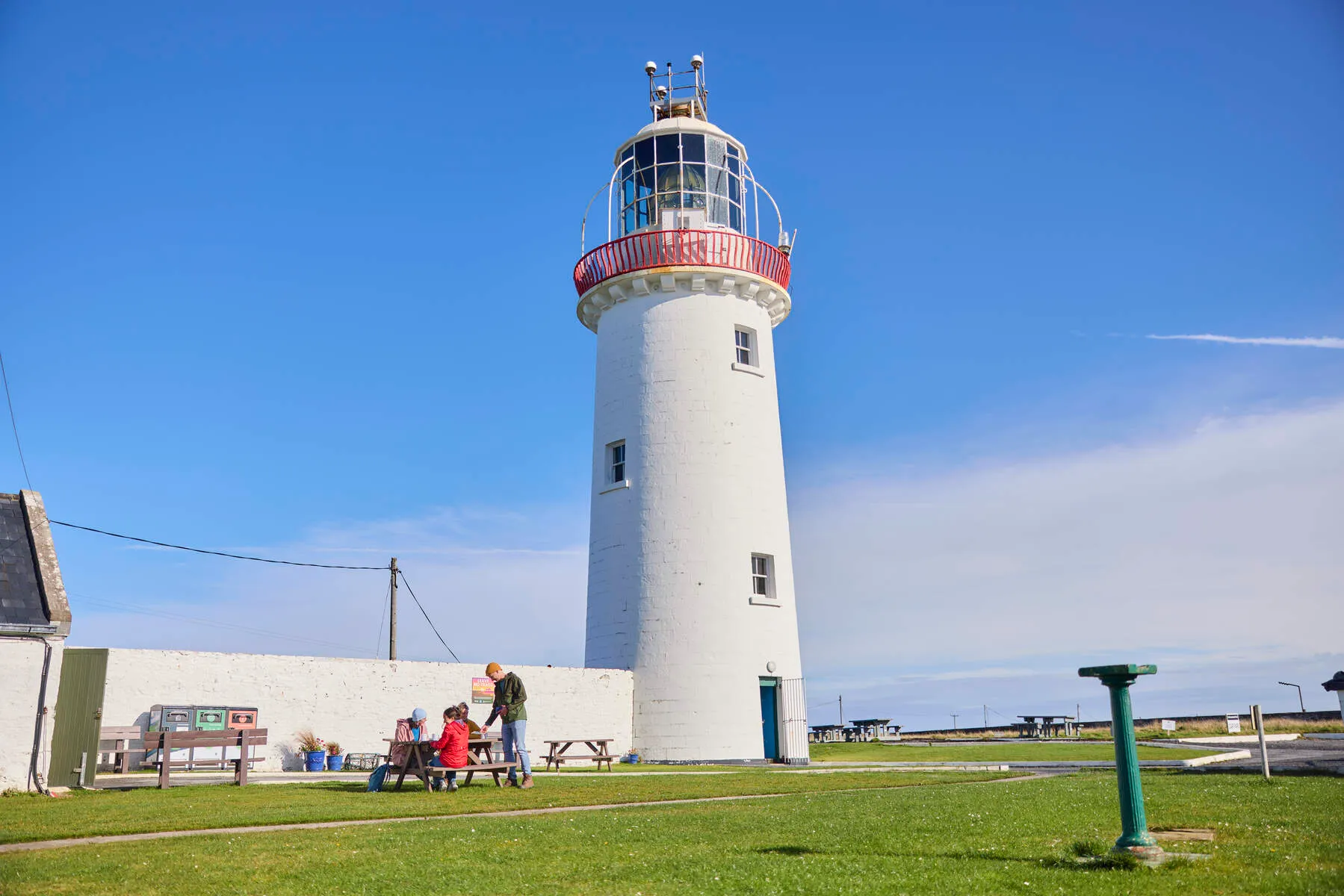
- First light established in 1802; the current 23-metre stone tower dates from 1854.
- Automated in 1991 and now operated by the Commissioners of Irish Lights.
- Visiting: Guided tours (≈ €8 adults, €5 children) let you climb the tower and enjoy 360° views that stretch from the Blasket Islands to the Twelve Pins in Connemara on a clear day.
- Parking: A small car park sits right beside the lighthouse, and it is rarely full.
2.4 Carrickaholt Castle & Mayarta River
- Location: The village of Carrigaholt lies on the southern coast, about 12 km from the lighthouse.
- Highlight: The ruins of Carrigaholt Castle overlook a sheltered bay, which makes this the obvious place to stop and eat.
- Facilities: A few cafés serve fresh seafood and local craft beer, ideal fuel for the second half of the ride.
2.5 Derrynadivva Bay and Beach
- Why stop: This wide, sandy bay is a favourite among locals for surfing and windsurfing. The beach is accessible via a short unpaved lane off the R487.
- Scenery: With the cliffs framing the horizon, it’s a great place to stretch your legs and watch seabirds such as puffins, guillemots and the occasional gannet.
3. Planning Your Ride
3.1 Best Time to Ride
| Season | Pros | Cons |
|---|---|---|
| Late Spring (May-June) | Long daylight (up to 17 h), wildflowers, milder winds. | Occasional rain showers. |
| Summer (July-August) | Warmest temperatures (15-20 °C), most services open. | Higher tourist traffic, occasional strong Atlantic gusts. |
| Early Autumn (September) | Fewer crowds, still warm, autumn colours. | Weather can become unpredictable. |
| Winter | Very quiet, dramatic storm-cloud scenery. | Short daylight, high winds (up to 100 km/h), road icing possible. |
Recommendation: Late May to early September gives the best balance of weather, daylight and amenities.
3.2 Bike Choice & Gear
- Bike type: A gravel bike or a road bike with wider tyres (28-32 mm) works best. The route is mostly paved, but the Kilkee Cliff Walk and occasional farm lanes benefit from a bit of tyre width and lower pressure.
- Essential gear:
- Waterproof jacket and bib trousers (the Atlantic can be wet even in summer).
- Sturdy shoes with good grip for the unpaved sections.
- A compact first-aid kit, spare inner tube, and a multi-tool.
- A high-visibility vest, the road can be narrow and windy.
- Portable power bank for phone navigation (offline maps recommended).
3.3 Navigation & Maps
- Offline maps: Download the Loop Head Heritage Trail GPX from the ActiveMe app or use the Komoot “Loop Head Peninsula Loop” route.
- Signage: The R487 is well-signed, but side-roads to attractions (e.g., Bridges of Ross) may lack markings, keep the GPX file handy.
- Phone coverage: Generally good along the main road, but may drop in the far-north tip; plan for offline navigation.
3.4 Accommodation & Food
| Type | Options | Notes |
|---|---|---|
| B&B / Guesthouse | The Diamond Hotel (Kilkee), Carrigaholt House, Lough Eske Hotel (nearby) | Book early in July-August. |
| Lighthouse Stay | Lightkeeper’s House at Loop Head (self-catering, sleeps 5, dog-friendly) | Unique experience; book at least 4 weeks ahead. |
| Camping | Kilkee Camping & Caravan Park, basic facilities, close to the cliff walk. | Ideal for cyclists with gear. |
| Food | Kilkee’s The Diamond Café (breakfast), The Harbour Bar (Carrigaholt), fresh fish and local produce. | Carry snacks for the long stretches between villages. |
3.5 Getting There
- By car: The R487 is accessed from the N67 at Kilkee. Ample free parking is available at Kilkee, Loop Head Lighthouse and Carrigaholt.
- Public transport: Bus Éireann route 350 links Ennis to Kilkee (approx. 1 h 30 min). From Kilkee, the loop is best tackled on bike.
- Bike hire: LoopHeadBikes.ie offers road, gravel and e-bike rentals, complete with helmets and map kits.
4. Safety and Environmental Tips
- Wind awareness: The peninsula is exposed; gusts can exceed 100 km/h in winter. If winds exceed 50 km/h, consider postponing the ride or using an e-bike to reduce effort.
- Cliff safety: The cliffs are unguarded. Keep a safe distance from the edge, especially on wet or windy days.
- Road etiquette: The R487 is a two-lane road shared with cars and agricultural vehicles. Signal early and ride predictably.
- Wildlife respect: The area is a Special Area of Conservation. Keep dogs on a leash near bird nesting sites and avoid disturbing wildlife.
- Leave no trace: Pack out all litter, carry a small bag for stray rubbish, and stick to established paths to protect fragile vegetation.
5. Sample Itinerary: 65 km Loop
| Time | Distance | Activity |
|---|---|---|
| 08:00 | 0 km | Start in Kilkee, coffee at The Diamond Café |
| 08:15-09:30 | 12 km | Follow R487 south, stop at Kilkee Cliff Walk viewpoint |
| 09:45-10:30 | 8 km | Detour to Bridges of Ross (short walk to sea arches) |
| 10:45-12:30 | 15 km | Ride to Loop Head Lighthouse, take a guided tour (≈ 45 min) |
| 12:45-13:30 | 5 km | Lunch at The Lighthouse Café (sandwiches, soup) |
| 13:45-15:15 | 12 km | Continue east to Carrigaholt, explore castle ruins, optional beach walk |
| 15:30-16:30 | 8 km | Return via inland road through Ross, optional stop at Derrynadivva Bay |
| 16:45-17:30 | 5 km | Arrive back in Kilkee, pint at The Harbour Bar to celebrate |
Total ride time (including stops): ~9 hours. Adjust start time and rest breaks according to fitness and daylight.
6. Frequently Asked Questions
Q: Is the Loop Head Lighthouse open year-round?
A: Yes, the lighthouse is open daily, but tours are reduced in winter (typically 10 am-4 pm). Check the official site for seasonal hours.
Q: Can I ride the loop on an electric bike?
A: Absolutely. E-bikes are popular on the peninsula, especially when headwinds are strong. Remember to obey local speed limits (max 25 km/h on public roads).
Q: Are there any alternative shorter loops?
A: The Kilkee-Ross Loop (≈ 30 km) skips the lighthouse and focuses on the northern cliffs. It’s ideal for families or riders with limited time.
Q: What wildlife might I see?
A: Seabirds (gannets, puffins), marine mammals (dolphins, seals), and, during migration, thousands of passerines pass through the peninsula’s cliffs.
Conclusion
Loop Head is not a hard ride by the numbers. Around 820 metres of climbing spread over 60-70 km, on paved road for nearly all of it. What makes it demanding is the exposure. Get the wind wrong and the flat sections feel like climbs; get it right and you will be back in Kilkee an hour before you expected. Check the forecast the night before, and be willing to ride it the other way round, or to leave it for another day.
The lighthouse tour is worth the money and the three-quarters of an hour. So is the walk out to the Bridges of Ross, even with only the one arch left standing.